The Land of Heart’s Delight – Early Maps and Charts of Vancouver Island.
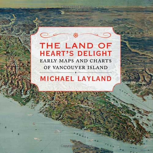
This book tells the fascinating story of more than two centuries (16-18th centuries) of marine explorations of the whole Northwest region of the American continent.
This post contains Amazon Affiliate links for which I may receive compensation.
Did you know that George Vancouver, who gave his name to the city of Vancouver and Vancouver Island, British Columbia, was part of two of James Cook”s oceanic expeditions? Did you know that Americans and British debated and negotiated for more than 30 years about the ownership of a few islands located between the North-American mainland and Vancouver Island? Do you know why the Northwest region of North America was extensively surveyed during the 18th century?
Well, you will learn about these historical facts, and much, much, much more, if you read this fascinating book by Michael Layland (The Land of Heart’s Delight – Early Maps and Charts of Vancouver Island.)
I know… I am using several superlative words here, but this book may be one of the most fascinating books I have read in my life.
I have lived in Canada for over 25 years and have visited this area of British Columbia, so I was first intrigued by a book that focused on such a niche topic. Being a hardcover book with over 130 reproductions of old maps, I imagined it would be a great coffee-table book for people living in the area. And it is certainly a beautiful book to own.
But it is much more than that. In great detail, the book tells the fascinating story of more than two centuries (16-18th centuries) of marine explorations of the whole Northwest region of the continent.
“The Northwest Coast of North America was the last part of the continent to be explored by Europeans,” explains Michael Layland, the book’s author.
We learn about the Spanish, Russian, British, and American interests in the region. We learn their motives for exploration, whether it is for the commerce of sea otters, in high demand in China, on a long quest to find a “Northwest passage” to the Atlantic Ocean, or later to establish trading posts.
We learn about James Cook’s 1778 expedition, the first to set foot on the island – unless Sir Francis Drake landed there first in 1579.
We learn about the unusual cooperation of two explorers, Spanish Bodega y Quadra and British George Vancouver, who – with their respective cartographers – surveyed and drew the first maps of Vancouver Island as an island, indicating in different colors the parts of the coastline each had surveyed (in fact George Vancouver had initially named the island Quadra & Vancouver Island, but the Hudson Bay Company and the Lords of the Admiralty later dropped the “Quadra” name from their maps).
We learn about the 1846 Treaty between the British and the Americans, which defined the border between their territories as “the middle of the strait” between Vancouver Island and the continent. The vagueness of the statement written by bureaucrats will make you smile if you looked at the body of water with its myriad of islands and at least two straits, the Haro Strait and the Rosario Strait. Only in 1872, after intense negotiations, was a final decision made about the localization of the border (the Haro Strait was chosen, to the advantage of the Americans.)
Then, in what I consider the second part of the book, Michael Layland tells us the story of the lives and work of all the men who painfully surveyed and mapped Vancouver Island and its surrounding waters in the second half of the 19th century.
Surveyors, hydrographers, topographers, and explorers at times, took years to add details to maps of the region, discovering new islands, changing the shape of coastlines, and exploring the most remote and mountainous parts of the island.
In the most detailed manner, we learn about their challenges and the map-making techniques they had to use (grid system, triangulation, photography). We learn what motivated the Hudson Bay Company and the successive governments to want better and better maps: settlements, railroads, tourism, etc.
It is no wonder Michael Layland spent eight years researching and writing this book. It is hard to imagine a more detailed story of mapping a single location (even though Vancouver Island is certainly not a small island, with its length of 390 miles, and poses particular cartography challenges with its numerous islands, rivers, lakes, and mountains.)
I have not studied cartography, and I am not a mapmaker (just someone who likes old maps and explorations), but I cannot think of a more enjoyable way to discover the practical challenges of map-making than this book. Michael Layland portrayed the daily lives of the men who mapped this region in a way that we almost feel we are there with them, traveling the countryside of Vancouver Island and navigating its waters.
I do have one suggestion, though. If you don’t know the region very well, find a map online that shows the region with the names of places mentioned in the book (such as Nootka Island, Cape Flattery, Georgia Strait of Georgia, the Juan de Fuca Strait, etc.). Otherwise, you will have a hard time visualizing which part of the region the author is talking about (this one is a good start: Map of Vancouver Island)
As I close this book, I realize that it even succeeded in making me wish that I’ll get a chance to visit Vancouver Island and its numerous islands again! And I hope many of you get to read Michael Layland’s book… and, of course, share your comments here (below) with us!

 Français